Backendless Version (3.x / 5.x, Online / Managed / Pro )
5.7.0 Free tier
Client SDK (REST / Android / Objective-C / Swift / JS )
JS
Application ID
073669A8-CCB7-2AED-FFEC-841A4CE5F400
Expected Behavior
- When the sample code in the documentation is executed for a 1:1 relation,
https://backendless.com/docs/js/data_relations_with_geo_points.html
var point = new Backendless.GeoPoint();

    point.latitude = 40.7148;
    point.longitude = -74.0059;
    point.categories = [ "taxi" ];
    point.metadata = { service_area : "NYC" };

    var taxi = { carmake:"Toyota", carmodel:"Prius" };

    // link one geopoint with the data object
    taxi.location = point;

    Backendless.Data.of( "Taxi" ).save( taxi )
    .then( function( savedObject ) {
    console.log( "taxi object has been saved" );
    })
    .catch( function( error ) {
    console.log( "error - " + error.message );
    });
-
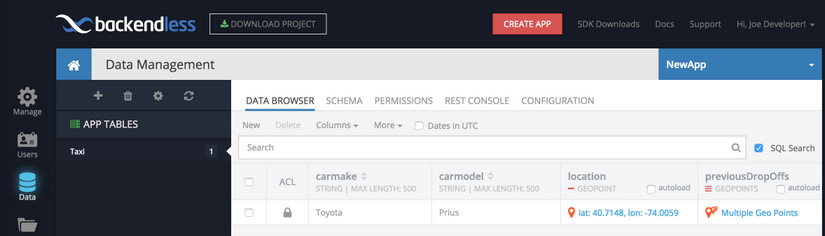
It creates a Geo Point under the location column as outlined in the example.
-
It creates the Geo Point under taxi under the Geolocation section

Actual Behavior
- Displays that the taxi object has been saved successfully
![]()
-
Does not actually save the Geo Point, however it saves rest of the object data.
-
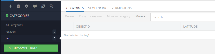
Does not save the Geo Point in the Category

Reproducible Test Case
Sample code is in the documentation itself
https://backendless.com/docs/js/data_relations_with_geo_points.html
For a 1:1 relation,
var point = new Backendless.GeoPoint();

    point.latitude = 40.7148;
    point.longitude = -74.0059;
    point.categories = [ "taxi" ];
    point.metadata = { service_area : "NYC" };

    var taxi = { carmake:"Toyota", carmodel:"Prius" };

    // link one geopoint with the data object
    taxi.location = point;

    Backendless.Data.of( "Taxi" ).save( taxi )
    .then( function( savedObject ) {
    console.log( "taxi object has been saved" );
    })
    .catch( function( error ) {
    console.log( "error - " + error.message );
    });
Thank you